EN

Translate:

  • HOME
  • MAPPING
  • MARINE
  • PRECISION
  • TRAINING
  • Contact us
  • About us
  • Product Spotlight
  • More
    • HOME
    • MAPPING
    • MARINE
    • PRECISION
    • TRAINING
    • Contact us
    • About us
    • Product Spotlight

EN

  • HOME
  • MAPPING
  • MARINE
  • PRECISION
  • TRAINING
  • Contact us
  • About us
  • Product Spotlight

SOFTWARE / INS SYSTEMS / ASV

ASV Vessels

Marine Software

Marine Software

Click to review the latest ASV available from OceachAlpha

show me more

Marine Software

Marine Software

Marine Software

click here to review all UAV models as well a addition payloads

show me more

INS Systems

Marine Software

INS Systems

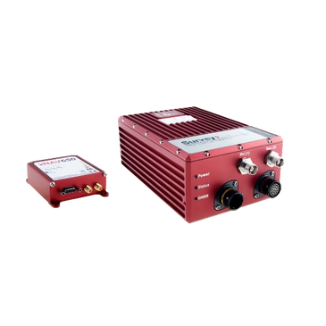
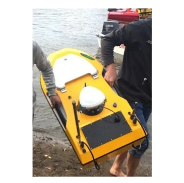
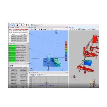
 This section has INS hardware and supporting                           software for data and sensor merging

show me more

OceanAlpha Sl40

Small Unmanned Surface Vehicle

  •  Multi-Function Small Unmanned Surface Vehicle for Hydrographic Survey   
  • Instruments, like ADCPs, echo sounders and side scan sonars, with a diameter of 5 cm to 18 cm, can be installed rapidly into the central moonpool, allowing you to switch between missions with ease. 
  •  SL40 can also be upgraded to a multi-beam echo sounder solution which has been proven to be highly mature and stable after repeated tests. 
  •  he innovative water jet thruster brings SL40 USV to a top speed 5m/s and effectively avoid being entangled by water plants or debris. 

End-To-End Solution

  •  The optional MBES model includes R2sonic 2020 and Hydro-Tech YH400P
  •  You can pre-program the survey mission with just a few drags and clicks on the base station computer. SL40 carrying instruments can conduct surveys autonomously and send back real-time data. 
  •  You can also drive SL40 by a remote controller to reach some difficult corners. 
  •  Equipped with radar sensors, SL40 USV can detect obstacles and avoid collision within 50 meters. 

Technical sheet

Want more information about this product? check out the manufacture technical sheet 

DOwnload now!

OceanAlpha Sl20

Autonomous Survey Boat

  • SL20 USV is designed for improving efficiency in hydrographic velocity / flow measurement and underwater mapping   
  •  The 177 mm-wide moon pool supports flexible deployment of different instruments like ADCPs and echo sounders.  
  •  The SL20 USV supports both remote control mode and auto-pilot mode, performs great line tracking capability  
  • The base station can be easily set up on field, data can be transmitted in real time. 
  • Waterjet  propulsion system drives the maximum speed to 5m/s

End-To-End Solution

  • The SL20 USV is 1 meter long and weights 17 kg, it’s easy for one man to operate and transport 
  • Powerful battery and low power consumption supports 6 hours of endurance at 3 knots.
  •  extremely low draft of 15cm, the SL20 USV allows you to survey freely on offshore coasts, shoals and reefs where traditional manned vessel unable to enter. 
  • Safety protection avoids the propellers being intertwined with water plants or water debris.

Technical sheet

Want more information about this product? check out the manufacture technical sheet 

DOwnload now!

Beamworx Suite

Multi-application collection suite

  • Hydrographic Survey with Single Beam, Multibeam and Laser scanner SL20 USV is designed for improving efficiency in hydrographic velocity / flow measurement and underwater mapping   
  •   Dredging operation on hoppers, cutters, excavators, grab dredgers etc 
  •  Laser scanning with drones and land based vehicles 
  •  General positioning calculation/visualization tasks both on- and offshore 
  •  Flexible geodetic coordinate conversion routines are available for most existing Coordinate Reference Systems, including geoid models 

End-To-End Solution

  •  Automatic cleaning and validation for Bathymetric and Lidar point clouds 
  • Calculates Roll/Pitch/Heading mounting angles, various latencies, Transducer offset shifts  
  • Includes despiking/outlier removal for sounder data
  • Imports and exports to various file formats, e.g. FAU/GSF/Kongsberg ALL+KMALL/PDS/ASCII/LAS/LAZ/Hypack HS2, HS2X/Grids
  • Stand-alone application with straight forward installer

Technical sheet

Want more information about this product? check out the manufacture technical sheet 

DOwnload now!

Hydromagic Software

Professional hydrographic survey package

  • Record sounding data using a (hydrographic) echo sounder and GNSS (RTK) receiver; 
  • Calculate volumes of river sections, pits, ponds, lakes and reservoirs, for instance in the mining industry; 
  • Create depth contours and save them as AutoCAD DXF or Google Earth, ESRI Shape or KML/KMZ files; 
  • Create a regularly spaced grid(s) from sounding data, and export it as DXF, KML or ASCII file;

End-To-End Solution

  • Built in raw data editor. Correct your raw data with echogram editor, position editor, filtering, PPK processing, latency correction and more 
  • Calculate tide levels using a RTK receiver, using a provided antenna height and loaded geoid model;
  • Use the built in coordinate calculator to convert hydrographic data files between different map projections. 
  • Supports any GNSS receivers (NMEA1083 compatible
  •  Import side scan sonar data files and use them as background map or map overlays 

Technical sheet

Want more information about this product? check out the manufacture technical sheet 

DOwnload now!

OxTS Survey+ V3 INS System

Flagship INS product for Land base and manned aircraft

  •  The Survey+ has for many years been recognized by companies worldwide as a powerful, high accuracy INS for measuring position and orientation in mobile mapping and other survey applications. 
  •   Yet it has always struck the perfect balance by continuously remaining one of the most affordable and cost-effective solutions for accurate land-based and manned aircraft mapping. 
  •  ready to seamlessly connect and use with the latest 3rd party hardware and software products for surveying and mapping 

End-To-End Solution

  • Tightly-coupled processing engine OxTS gx/ix technology – uses inertial and raw GNSS measurements to generate the best possible navigation solution in challenging environments   
  • Precision positioning – the best centimetre level position accuracy of any of our surveying and mapping solutions to date.
  • Synchronize multiple external devices – the v3 features 3 ethernet ports and 3 serial ports as well as the ability to integrate external GNSS receivers too 

Technical sheet

Want more information about this product? check out the manufacture technical sheet 

DOwnload now!

OxTS xNAV650 INS System

Small in size but huge potential

  • Measuring only 77 x 63 x 24 mm the xNAV650 is our smallest INS to date. Its small form factor is ideal for any application where space is limited making it ideal for UAV-based mapping.
  •  When weight is a factor look no further than the xNAV650 INS. Weighing just 130 g, the xNAV650 is the ideal partner when precision is crucial, but the payload needs to be as light as possible. A lighter payload and lower power consumption means longer flight times for UAVs 
  • Quad constellation (GPS, GLONASS, BeiDou and Galileo) as standard means that users  can benefit from 2 cm position accuracy even in the most challenging GNSS environments.

End-To-End Solution

  •  The xNAV650 INS benefits from optional precision time protocol (PTP) time stamping functionality    
  • OxTS gx/ix tight-coupling technology ensures that users of OxTS inertial navigation systems receive the most accurate measurements possible even in tough GNSS conditions such as urban canyons..
  •  OxTS Georeferencer allows users of OxTS’ inertial navigation systems to georeference pointclouds from almost any LiDAR sensor 

Technical sheet

Want more information about this product? check out the manufacture technical sheet 

DOwnload now!

OxTS navsuite / georeferencer for survey and Mapping

Configure, monitor, post-process and analyse your data

  • Configure – NAVconfig allows users to configure their INS to ensure they are getting the best possible data.
  • Monitor – Using NAVdisplay, surveyors can ‘see what their OxTS INS is seeing’, and monitor their data in real-time.
  • Post-process – Surveyors can use NAVsolve to post-process their survey data.
  • Analyse – NAVgraph allows users of OxTS INS devices to read and interpret the data in graphical form. Ideal for troubleshooting.
  •  Processing options - OxTS Georeferencer includes a large range of processing options based on accuracy, range, speed, and angle. It also gives users the ability to add into the pointcloud point normal and trajectory data. 

End-To-End Solution

  •  OxTS Georeferencer includes an optional boresight calibration feature.  Eliminate double-vision / Minimize blurring and maximize precision / Collect calibration data in minutes 
  •  Accuracy estimation - OxTS Georeferencer includes a formula for estimating the uncertainty in point positions based on INS and LiDAR accuracy at each moment of the survey  
  •  Global coordinates - The user has the option to process in a range of coordinate systems including local coordinates, ECEF and LLA (latitude, longitude and altitude) 

Technical sheet

Want more information about this product? check out the manufacture technical sheet 

DOwnload now!

Our Partners

Contact Us

Better yet, see us in person!

We love our LiDAR customers, so feel free to visit

Canadian LiDAR And Mapping

40 Ashburn Lake Road, Saint John, New Brunswick E2J 5E2, Canada

5066503097

Hours

Open today

09:00 a.m. – 05:00 p.m.

Drop us a line!

This site is protected by reCAPTCHA and the Google Privacy Policy and Terms of Service apply.

Cancel

info@canadianlidar.ca


Copyright © 2022 Canadian Lidar & Mapping