

MULITBEAM / SONARS / SIDESCAN

mULTIBEAM SYSTEM
SIDESCAN SBP SYSTEMs
mULTIBEAM SYSTEM
click here to review all UAV models as well a addition payloads
ECHO SOUNDER
SIDESCAN SBP SYSTEMs
mULTIBEAM SYSTEM
for all your Total station, GNSS, Mapping and Accessories Needs
SIDESCAN SBP SYSTEMs
SIDESCAN SBP SYSTEMs
SIDESCAN SBP SYSTEMs
for all your Total station, GNSS, Mapping and Accessories Needs
Geoswath 4

Industry-leading wide swath bathymetry and side scan
- Ultra high-resolution swath bathymetry
- Up to 12 times water depth seabed coverage
- 240° field of view – up to the water line
- Latest GS4 software included
- Available in 125, 250, and 500 kHz versions.
- Co-registered, geo-referenced side scan
- Ruggadised portable solution.
End-To-End Solution
- The GeoSwath 4R also includes a dual transducer head with a 240º field of view from nadir to waterline, enabling bottom coverage of up to twelve times the water depth. Transducers have a versatile range of mounting options and are available in 125, 250 or 500 kHz versions, each varying in depth and data resolution to optimise performance for the individual survey task.

Technical sheet
Want more information about this product? check out the manufacture technical sheet
Geoswath 4r
Next-Generation Wide Swath Bathymetry
- Ultra high-resolution swath bathymetry
- Up to 12 times water depth seabed coverage
- 240° field of view – up to the water line
- Latest GS4 software included
- Available in 125, 250, and 500 kHz versions.
- Co-registered, geo-referenced side scan
- Ruggadised portable solution.
End-To-End Solution
- GeoSwath 4R offers industry-leading simultaneous swath bathymetry and side scan sonar mapping for shallow waters, and comes with a compact, splash-protected deck unit housing and ruggedised laptop, making it the ideal solution for surveying in rougher conditions.

Technical sheet
Want more information about this product? check out the manufacture technical sheet
Geoswath 4 usv
GeoSwath Module for USV Installation
- Ultra high-resolution swath bathymetry
- Up to 12 times water depth seabed coverage
- 240° field of view – up to the water line
- Latest GS4 software included
- Available in 125, 250, and 500 kHz versions.
- Suitable for installation in a range of USVs
- Ruggedized portable solution.
- Available as a stand alone module or mounted on a base plate with DIN rail mounted connections
End-To-End Solution
- The GeoSwath 4 utilises a dual transducer head that provides bottom coverage up to twelve times the water depth and delivers data accuracies that exceed IHO hydrographic survey standards. The geo-referenced side scan data can be calibrated for repeatable results to provide enhanced object detection and bottom classification.

Technical sheet
Want more information about this product? check out the manufacture technical sheet
Geoswath phs
Complete package for bathymetric surveying
- GeoSwath 4R bathymetric system
- GNSS position & heading sensor
- Motion reference unit
- Sound velocity sensor
- Sound velocity profiler
- Over the Side mount
- GeoSwath software
End-To-End Solution
- As well as the required external sensors the GeoSwath PHS is also supplied with the tried and tested Over The Side Mount. This mount is also compatible with the GeoPulse, GeoPulse Pipeliner and GeoPulse Compact range of sub-bottom profilers. The GeoSwath 4 utilises a dual transducer head that provides bottom coverage up to twelve times the water depth and delivers data accuracies that exceed IHO hydrographic survey standards. The geo-referenced side scan data can be calibrated for repeatable results to provide enhanced object detection and bottom classification.

Technical sheet
Want more information about this product? check out the manufacture technical sheet
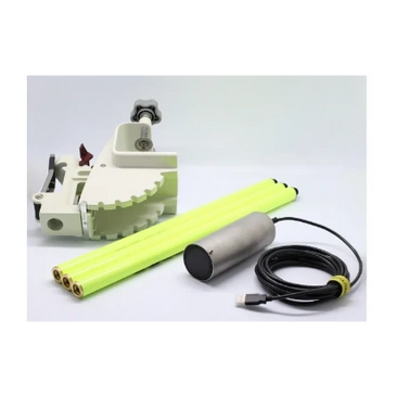
Geoswath pulsar
Complete package for bathymetric surveying
- Easy deployment and operation
- Portable and rugged towfish
- 550 – 1000 kHz frequency range
- Wide bandwidth FM and CW pulses
- Integrated GPS module
- Compact, water-protected deck unit
- Exclusive Pulsar acquisition and processing software
- Available with dedicated version of Chesapeake’s SonarWiz acquisition software
End-To-End Solution
Rugged and accurate hardware solution coupled with easy to use field APP interfaces. Download data via USB or Wi-Fi to register, adjusted and georeferenced point cloud dataset

Technical sheet
Want more information about this product? check out the manufacture technical sheet
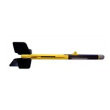
Geopulse compact ots
Rugged and high-performance sub-bottom profiler
- Lightweight and rugged
- Low power consumption
- Good results in water as shallow as 1m
- Wide frequency rang
- Wide-beam reception for pipeline detection
- In-field upgradeable firmware
- Chesapeake’s SonarWiz software for acquisition
- Supplied with 10m deck cable as standard
End-To-End Solution
Rugged and accurate hardware solution coupled with easy to use field APP interfaces. Download data via USB or Wi-Fi to register, adjusted and georeferenced point cloud dataset
Technical sheet
Want more information about this product? check out the manufacture technical sheet
Single / Dual Frequency Echo Sounder
Ultracompact echo sounder for surface vehicles
- User friendly GUI software provided for instant image update
- Plug and Play on a PC via USB port (EU400)
- Compatible with Beamworxs, QPS, Hypack, HydroMagic, ReefMaster and HydroPro(Trimble)
- Serial interface (RS232, 485, 422) (ECT400S)
- Tilt sensor integrated(option)
- Depth rate up to 6,000m
End-To-End Solution
- Real-time backscatter data collection along full water columns
- Buad rate up to 3Mbaud for ping rate up to 100 Hz
- Fluid mud layer detection
- Sediment monitoring
- 50/200kHz, 30/200kHz

Technical sheet
Want more information about this product? check out the manufacture technical sheet
Our Partners


Contact Us
Better yet, see us in person!
We love our LiDAR customers, so feel free to visit
Canadian LiDAR And Mapping
40 Ashburn Lake Road, Saint John, New Brunswick E2J 5E2, Canada
Email: info@canadianlidar.ca Phone: 506 650-3097
Hours
Open today | 09:00 a.m. – 05:00 p.m. |
