

excavator systems
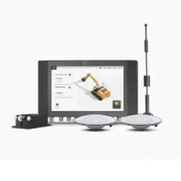
3D Excavator System
Smart Piling System
Smart Piling System
3cm Accuracy / 3D Visual Guidance

Smart Piling System
Smart Piling System
Smart Piling System
Precise 3D positioning pile head / Drill hole
2D Excavator System
Smart Piling System
2D Excavator System
Affordable price / wireless modules
3D excavator guidance system

Higher Efficiency with Reduced Cost
- The GNSS and RTK-based grade control system features a 3D reference model, updates cut & fill workload, and displays excavator and bucket position in real time, so operators of all skill levels can easily achieved accuracy of 3cm.
- Using FJD G31 3D excavator guidance system simplifies the repetitive steps of lofting,
piling and measuring in traditional construction, making construction easier and more efficient.
Any Machine Any Age
- Visually view the task progress, slope, depth, construction reference point. Through the image of the control terminal to ensure the quality of construction
- operators can import drawing files in three models - depth settings, CAD design file import, or custom design
- instead of carrying a USB of the job site as used to, operators can now transfer files directly over the network
- records the current position of the selected bucket tip, and start the next operation from where it ended last time. This function is suitable for underwater digging and other working scenarios
- Elevation offset breaks down the excavation process with achievable surfaces, so the target can be reached step by step, leading to a refined result finally
Digital Construction Platform
- Construction platform monitors the whole workflow in real time.
The management of machines, materials, human resources etc. can be checked by site-manager at anytime and anywhere.

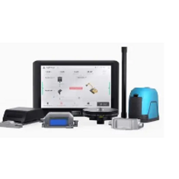
2D Easydig G21 2D Excavator Guidance System
This is Easydig
- Easydig is a wireless 2D excavator guidance system that leads the industry with centimeter accuracy. It’s so easy to use that even newbies can get started quickly.
- The 2D excavator guidance system comes with a modular design that allows you to switch between machines. Every operator can get it at an affordable price.
Key Benefits
- Digital Construction vs. Traditional Construction 35% less labor hours, 67.5 reduced labor costs and 35% less diesel
- 2cm accuracy enabled by algorithm lets you know the precise position of the bucket teeth, so you can avoid over-dig or under dig and cut slopes to your desired grade
- set your target depth, width, length and grade right on the site and get started in no time
Tool for Any Project
- 3D real-time animation guidance helps avoid repeated measurements and rework
- The HMI system provides 8 perspectives and 4 interface view modes, which can be freely combined and presented according to work habits and needs
- With the modular and wireless design, this 2D excavator grade control system is easy to set up and switch between machines

Smart Pile driver guidance System
Centimeter Accuracy
- The product applies high-precision GNSS and RTK technology, which enables operator to get real-time and precise 3D position information of the pile head and drill rod, making the drilling operation digitalized.
- This system applies high-precision GNSS real-time kinematic positioning technology,
leading to precise alignment and cm-level piling accuracy.
Streamline process for field crews
- The operator can quickly and accurately locate piles under the guidance of the control terminal, without setting out and marking in advance. Labor and management costs are reduced while greatly improving efficiency.
- The vertical deviation of the drill rod is shown in real time on the industrial grade control terminal to help the operator straighten the drill rod accurately. The system will instruct operators to proceed to the next step when the drill rod is adjusted properly.
Attitude Adjustment
- Pile position could be imported with one button and displayed on the control terminal.
The operator can use this information to facilitate the drilling process. - Drilling quality is guaranteed by GNSS-based cm-level RTK positioning and 0.1° accuracy orientation. Construction process will be digitalized, allowing real-time monitoring of drilling depth and rock-socketed depth
Want more information or pricing
Better yet, see us in person!
We love our customers, so feel free to visit during normal business hours.
Hours
Open today | 09:00 a.m. – 05:00 p.m. |


Payments Options
We have 30 years of equipment financing experience and background. Our leasing professionals have vast experience and knowledge with small-medium business needs.
Contact Us
Better yet, see us in person!
We love our LiDAR customers, so feel free to visit
Canadian LiDAR And Mapping
40 Ashburn Lake Road, Saint John, New Brunswick E2J 5E2, Canada
Email: info@canadianlidar.ca Phone: 506 650-3097
Hours
Open today | 09:00 a.m. – 05:00 p.m. |
